Big data analytics makes its way into the Indian agriculture sector through SatSure
By working closely with the government and financial institutions, SatSure aims to ensure that the country’s agricultural growth corresponds to our food security, along with the financial security of farmers.
India grapples with immediate challenges such as depleting groundwater resources, climate change, extreme events like droughts and floods. Due to the lack of fair and timely compensation for losses incurred and the lack of transparency in fixing the fair price for the produce combined with the difficulty in access to markets, there is a need for the agrarian society to explore technology as a medium to mitigate both farm and financial distress.
Deeply moved by farmer suicides and debt, lack of access to scientific agricultural practices, dwindling farm holding sizes, and institutional apathy, 33-year-old Abhishek Raju founded SatSure, a data analytics company which integrates satellite, weather, and IoT analytics with the agriculture sector in 2015.
We at SatSure firmly believe that technology is an enabler of change, and can be used for doing good in the society, says Abhishek.
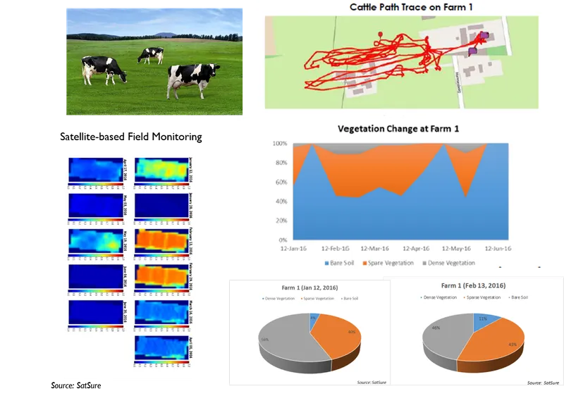
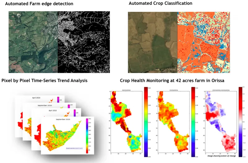
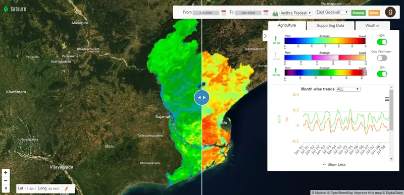
Although satellite data have been used to monitor the agricultural sector for the last three decades, Abhishek believes that the complex relationships between parameters governing crop growth and soil health have had a limited scope within the research community. SatSure uses its proprietary machine learning and parallel computing techniques, to resolve these complex relationships and get insights into the crop phenology.
“The motto of our national space programme has always been to use satellite applications for national development. As products of Dr Vikram Sarabhai’s vision, we chose to take the entrepreneurship route for building on the good work done by ISRO and assisting in the commoditisation of satellite-based solutions, which is the core for investing in space technology — trickle-down economics,” he adds.
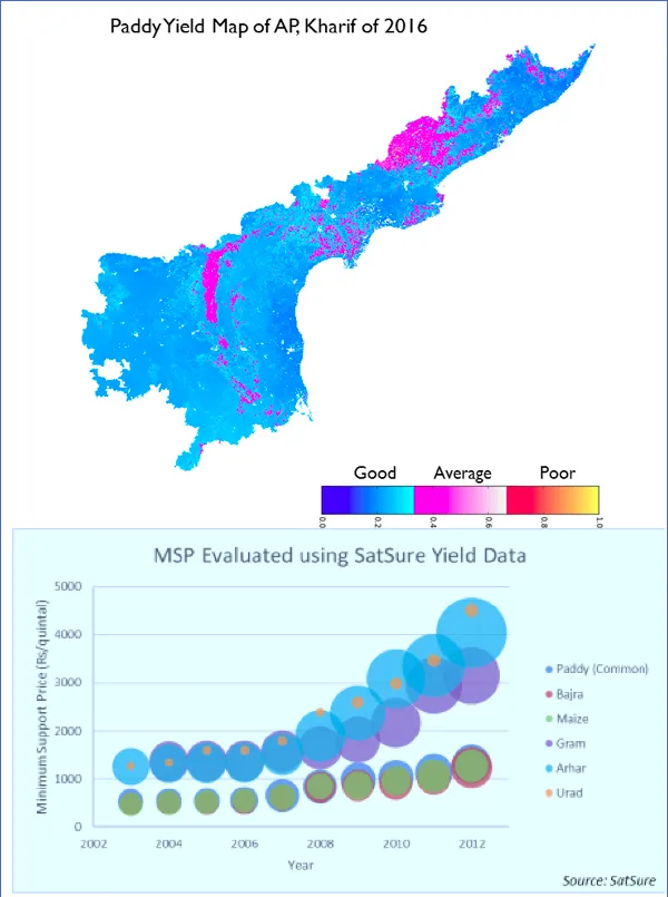
Explaining further he says that the current practice of crop cutting experiments (CCEs), to get an estimation of total agricultural production, is both a manual and time intensive process. Instead, farmers can opt for smart sampling procedure using satellite-based crop clustering techniques, which reduces the time for identification of these plots and optimise their locations.
Satellite imaging for financial security and crop insurance
Though satellites have applications in many domains, the 18-member-team was inspired to work in the agriculture sector because they believed that a well-thought satellite-based solution can have a large scale impact in this space.
Abhishek explains,
The spate of farmer suicides and measly compensation received by farmers for their losses motivated us to work towards improving the sustainability of agriculture, by addressing the basic need of this sector – ensuring financial security of the vulnerable by supporting institutional mechanisms in place through good macro and micro data.
Over the past two years, SatSure has demonstrated a strong correlation between satellite-derived proprietary crop-related parameters and ground data, which can be exploited by the agri-insurance sector. To facilitate these solutions at a national scale, the organisation is building a 15-year archive of remotely sensed satellite images over the Indian subcontinent, using images from multiple satellites that have been in operation since 2002.
While the farmer requires timely crop intelligence, crop insurance companies need highly accurate assessment of risk. The satellite imaging analytics serve two purposes: first, it ensures that the farmers receive a fair and immediate compensation for crop loss due to adverse climatic conditions. Second, it enables insurers to settle claims speedily due to the availability of data in near-real time without any manual intervention.
Enabling policies and digitisation is the future
Modernisation has not impacted farmers in India in a meaningful way and the impact has been largely limited to farmers with surplus income and large land holdings. Most of the farmers are still dependent on the monsoon for irrigation throughout the year. Many are caught in an unending cycle of debt which affects their ability to invest more in modern agricultural techniques and natural calamities only worsen the situation.
Frequent loan waivers and compensating for harvest losses that are not representative of the actual losses incurred by the farmer are few of the examples of how the domestic agriculture sector has been oblivious to the advancement in technology for adapting to climate risks. There is a host of mobile and web applications catering to the agricultural sector, but Abhishek believes that there exists a gap between the user requirement and available technology.
He adds,
We have seen the difference internet and mobile technology has brought about in our society. Satellite technology and its applications are the next level for a transforming India to continue and position India as the ‘knowledge-driven economy’.
The United Nations and World Bank backed pilot projects on drought insurance for farmers in developing countries have been successful. However, most of these projects failed at large scale implementation, and the primary reason being the lack of state backing and hesitant private insurance companies due to the absence of historical data.
However, in the past decade, the government policies in agriculture and ICT technology have been encouraging. Under the FASAL project, production forecasting of crops using remote sensing data was initiated by ISRO in 2008. It includes forecast of disease and damage detection; and development of techniques for crop insurance. This has also been incorporated in the Pradhan Mantri Fasal Bima Yojana (Prime Minister’s Crop Insurance Scheme) and other government schemes with the aim of doubling farmer incomes by 2022.
“Our aim is to provide technology-based solutions for agriculture on a national level. Since most of the phenomenon related to agriculture are complex and highly interdependent processes, a lasting solution from the policy-makers is still some years away. This is the gap that SatSure wants to plug,” he says.