ISRO successfully launches PSLV-C34, places 20 satellites in a single launch
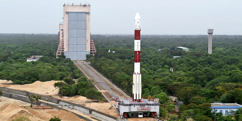
In its thirty-sixth flight, Indian Space Research Organisation's (ISRO) Polar Satellite Launch Vehicle(PSLV-C34) successfully launched the 727.5-kg Cartosat-2 Series Satellite along with 19 co-passenger satellites on Wednesday morning, from Satish Dhawan Space Centre SHAR, Sriharikota. This is the thirty-fifth consecutively successful mission of PSLV and the fourteenth in its 'XL' configuration. ISRO reported that the total weight of all the 20 satellites carried on-board PSLV-C34 was 1,288 kg.

Image credit- ISRO gallery
All systems clear
The 48-hour countdown began yesterday at 9.26 am for the launch of 20 satellites on board PSLV-C-34 from Sriharikota, after the launch authorisation board (LAB) gave its nod and filling of Mixed Oxides of Nitrogen (MON-3) of PS4 was completed yesterday.
The countdown exercise encompassed spacecraft health checks and preparations for propellant-filling operation of second stage (PS2) of PSLV-C34 is in progress. Cartosat-2 Series is similar to the earlier Cartosat-2, 2A and 2B, and 19 co-passenger satellites, together weighing about 560 kg at lift-off, would be injected into a 505-km polar Sun Synchronous Orbit.

Take off!
ISRO reported that after PSLV-C34 lifted off at 0926 hrs IST from the Second Launch Pad with the ignition of the first stage, the subsequent important flight events, namely strap-on ignitions and separations, first-stage separation, second-stage ignition, heat-shield separation, second-stage separation, third-stage ignition and separation, fourth-stage ignition and cut-off, took place as planned.
After a flight of 16 minutes 30 seconds, the satellites achieved a polar Sun Synchronous Orbit of 508 km inclined at an angle of 97.5 degree to the Equator (very close to the intended orbit), and in the succeeding 10 minutes, all the 20 satellites successfully separated from the PSLV fourth stage in a predetermined sequence.
After separation, the two solar arrays of Cartosat-2 series satellite were deployed automatically and ISRO's Telemetry, Tracking and Command Network (ISTRAC) at Bengaluru took over the control of the satellite.
In a series of tweets, Indian Prime Minister Narendra Modi expressed his good wishes to the ISRO team on its accomplishment.
Modi also went on to state:
Our space programme has time and again shown the transformative potential of science & technology in people's lives. Over the years we developed expertise & capability to help other nations in their space initiatives. This is the skill of our scientists.
Breakdown of the 20 satellites
ISRO reported that of the 19 co-passenger satellites carried by PSLV-C34, two – SATHYABAMASAT weighing 1.5 kg and SWAYAM weighing 1kg – are University/Academic institute satellites and were built with the involvement of students from Sathyabama University, Chennai and College Of Engineering, Pune, respectively.
The remaining 17 co-passenger satellites were international customer satellites from Canada (2), Germany (1), Indonesia (1) and the United States (13).
The mission would carry LAPAN A3 of Indonesia, BIROS of Germany, SKYSAT GEN 2-1 of US, MVV of Germany among the micro satellites, ISRO sources had earlier said to PTI.
With today’s successful launch, the total number of satellites launched by India’s workhorse launch vehicle PSLV has reached 113, of which 39 are Indian and the remaining 74 from abroad.
What next?
In the coming days, the satellite will be brought to its final operational configuration, following which it will begin to provide remote sensing services using its panchromatic (black and white) and multispectral (colour) cameras.
ISRO adds that the imagery sent by the Cartosat-2 series satellite will be useful for cartographic applications, urban and rural applications, coastal land use and regulation, utility management like road network monitoring, water distribution, creation of land use maps, precision study, change detection to bring out geographical and man-made features and various other Land Information System (LIS) and Geographical Information System (GIS) applications.


![[Startup Bharat] This Indore-based security startup is securing your infrastructure data using a hacker’s point of view](https://images.yourstory.com/cs/2/a9efa9c0-2dd9-11e9-adc5-2d913c55075e/startup-bharat-feature-img21550042933391.jpg?mode=crop&crop=faces&ar=1%3A1&format=auto&w=1920&q=75)